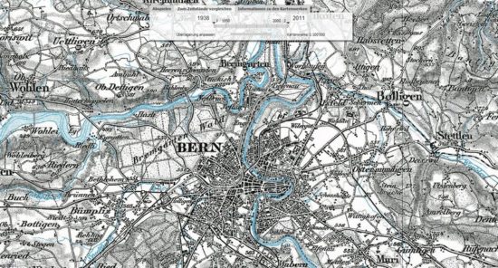
On the occasion of its 175th anniversary, the Federal Office of Topography Swisstopo lets us travel back in time. The new one shows how Switzerland has been built over the last few decades Web App and sends the viewer on a journey through time.
Helvetia, how have you changed! Swisstopo has been measuring Switzerland for almost two hundred years and the data is constantly updated. As the federal geoinformation center, swisstopo is Switzerland's "landscape memory" that analyzes and documents changes in the landscape. To celebrate its 175th anniversary, a Viewer published for topographic maps, which to a certain extent enable a journey through time via a web browser. In this way, the Federal Office makes the data it has collected over the decades available to the general public. The web app shows how much the landscape has changed in Switzerland, as well as the phenomena of urban sprawl and the growth of agglomerations. For the time being, the last 75 years are available, from mid-2013 the journey through time will go back to 1838, the year the first Dufour map was published. The Federal Office of Topography is planning further highlights for the anniversary year. An interactive web platform is to be launched in March, which combines information and games on the subject of Swiss geography.
More for you:


 "Dravens Tales from the Crypt" has been enchanting for over 15 years with a tasteless mixture of humor, serious journalism - for current events and unbalanced reporting in the press politics - and zombies, garnished with lots of art, entertainment and punk rock. Draven has turned his hobby into a popular brand that cannot be classified.
My blog was never designed to spread news, let alone get political, but with current affairs I just can't help but capture information here that is otherwise censored on all other channels. I am aware that the design page may not seem "serious" to many in this regard, but I will not change this to please the "mainstream". Anyone who is open to non-state-compliant information sees the content and not the packaging. I've tried enough to provide people with information over the last 2 years, but quickly noticed that it never matters how it's "packaged", but what the other person's attitude towards it is. I don't want to put honey on anyone's mouth to meet expectations in any way, so I'll keep this design because hopefully at some point I'll be able to stop making these political statements, because it's not my goal to go on like this forever ![]() I leave it up to everyone how they deal with it. However, you are welcome to simply copy and distribute the content, my blog has always been under the WTFPL license.
I leave it up to everyone how they deal with it. However, you are welcome to simply copy and distribute the content, my blog has always been under the WTFPL license.
It's hard for me to describe what I'm actually doing here, DravensTales has become a culture blog, music blog, shock blog, tech blog, horror blog, fun blog, a blog about found items on the internet, internet bizarre, trash blog, art blog, water heater, zeitgeist blog over the years , Scrap blog and grab bag blog called. Everything that is right ... - and yet not. The main focus of the blog is contemporary art, in the broadest sense of the word.
To ensure the operation of the site, you are welcome to Make a donation by credit card, Paypal, Google Pay, Apple Pay or direct debit/bank account. Many thanks to all readers and supporters of this blog!